Seoul Mountains Part 1: Namsan, Inwangsan & Naksan — History, Walls and Night Views in the Heart of the City
Most people don’t immediately think of Seoul as a hiking city. They think of subways and skyscrapers, street food and shopping, palaces and pop culture. All of that is accurate. But Seoul is also a city built inside a ring of mountains — eight significant peaks that surround and define the old Joseon capital, with four sitting directly within the urban core — and the relationship between those mountains and the streets below them is one of the most interesting things about living in or visiting this city.
This three-part series covers Seoul’s mountains from closest and most accessible to most demanding and most rewarding. Part One is for anyone who wants to hike before dinner — three mountains that rise straight from the urban fabric, that can be reached by subway and walked without specialist gear, and that deliver something rarely found anywhere else in the world: genuine mountain views from the heart of a city of ten million people.
The three mountains in this chapter — Namsan, Inwangsan, and Naksan — are connected by the Seoul Fortress Wall, the ancient stone rampart that once enclosed the entire Joseon Dynasty capital. Walking any one of them is also, in part, walking along history. Walking all three in sequence, which the most ambitious visitors sometimes do in a single day, traces the full inner ring of the old city in a way that nothing else quite replicates.
Why Seoul’s Inner Mountains Are Special
To understand why these three particular mountains matter, it helps to know a little about how Seoul was designed.
When the Joseon Dynasty established its capital in 1394, the planners deliberately chose a site ringed by mountains, using the natural terrain as both a defensive framework and a spiritual one. Four inner mountains defined the cardinal directions of the new city: Bugaksan to the north, Namsan to the south, Naksan to the east, and Inwangsan to the west. The Seoul Fortress Wall — Hanyangdoseong — was built along the ridgelines of all four, connecting the peaks in a continuous loop of stone that was over eighteen kilometers long.
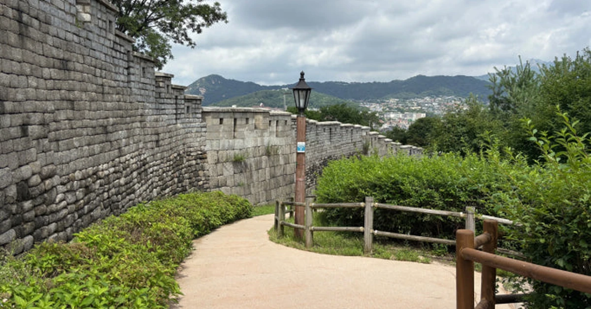
That wall still exists in substantial sections today, and hiking along its surviving stretches is one of the most distinctive experiences Seoul offers. You are walking on stones that have been part of this city’s identity for over six hundred years, with the modern skyline spread out below you and the old palaces occasionally visible between the rooftops. The combination of ancient infrastructure and contemporary urban landscape — visible together from the same elevated vantage point — is genuinely unlike anything else.
Namsan — The Mountain Everyone Knows and Not Everyone Climbs
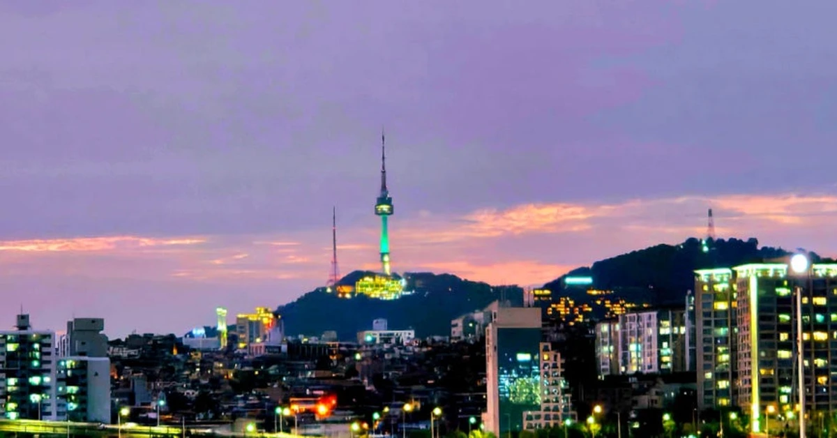
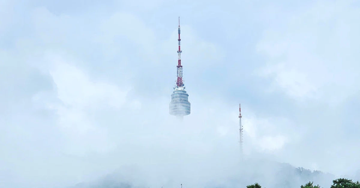
Namsan is Seoul’s most famous mountain, and also the one most visitors interact with only partially. The N Seoul Tower at the summit — visible from almost every elevated point in the city — draws enormous numbers of visitors who arrive by cable car or by the Namsan circular bus. Far fewer people walk up.
That’s worth correcting, because the walk up Namsan is one of the most pleasant urban hikes in Asia.
The mountain rises to 265 meters above sea level and sits in the geographic center of Seoul — north of the Han River, south of the palace district, equidistant from the old and new hearts of the city. From the summit, the view sweeps north toward Bugaksan and the mountains beyond, east toward the Gangnam skyline and the distinctive silhouette of Lotte World Tower, south toward the Han River curves, and west toward Incheon on a clear day. It is the most comprehensive single viewpoint available within Seoul’s city limits, which is why paying the additional fee to go up the tower itself — adding another few dozen meters of elevation — expands the view dramatically.
The most straightforward approach starts from Myeongdong Station on Line 4. Exit through Exit 3 and walk uphill following the signs for the Namsan Library trailhead. The walk from the subway exit to the summit takes about 45 to 90 minutes depending on pace and the specific route chosen — the pine-forested approach via the library area is the most pleasant, moving through shaded trails that feel immediately quieter than the streets below. The cable car, if energy or time is an issue, departs from near the base of the mountain and arrives at the summit in about three minutes.
What most visitors who arrive by cable car miss is the mountain itself — the way the forest canopy changes as elevation increases, the old fortress wall sections that appear along the ridge, the smaller shrines and pavilions tucked into the hillside below the tower. The Namsan Seoul City Wall section, running along the ridge, is one of the better-preserved stretches of the ancient fortification, and walking it is a different experience from simply arriving at the summit.

Namsan is also unique among Seoul’s mountains for functioning effectively at night. The tower is illuminated after dark, the walking trails are lit, and the view of Seoul at full city illumination — every building and bridge and arterial road glowing against the mountain dark — is genuinely spectacular. For visitors with limited time who can only hike one mountain in Seoul, this is the most practically accessible option and the one that works across the widest range of weather conditions, fitness levels, and schedules.

Practical details: Free entry to the mountain. Cable car costs around 9,500 won one way, 15,500 won return. The tower observatory has a separate entry fee. Trails are open year-round. Circular bus routes 02 and 05 from Myeongdong serve the mountain.
Inwangsan — The Ridge That Makes Seoul Make Sense

Ten minutes by subway from central Seoul, accessible from Gyeongbokgung Station on Line 3, Inwangsan is the mountain that experienced hikers in Seoul consistently name when asked which urban trail they’d recommend to someone who only has a few hours.
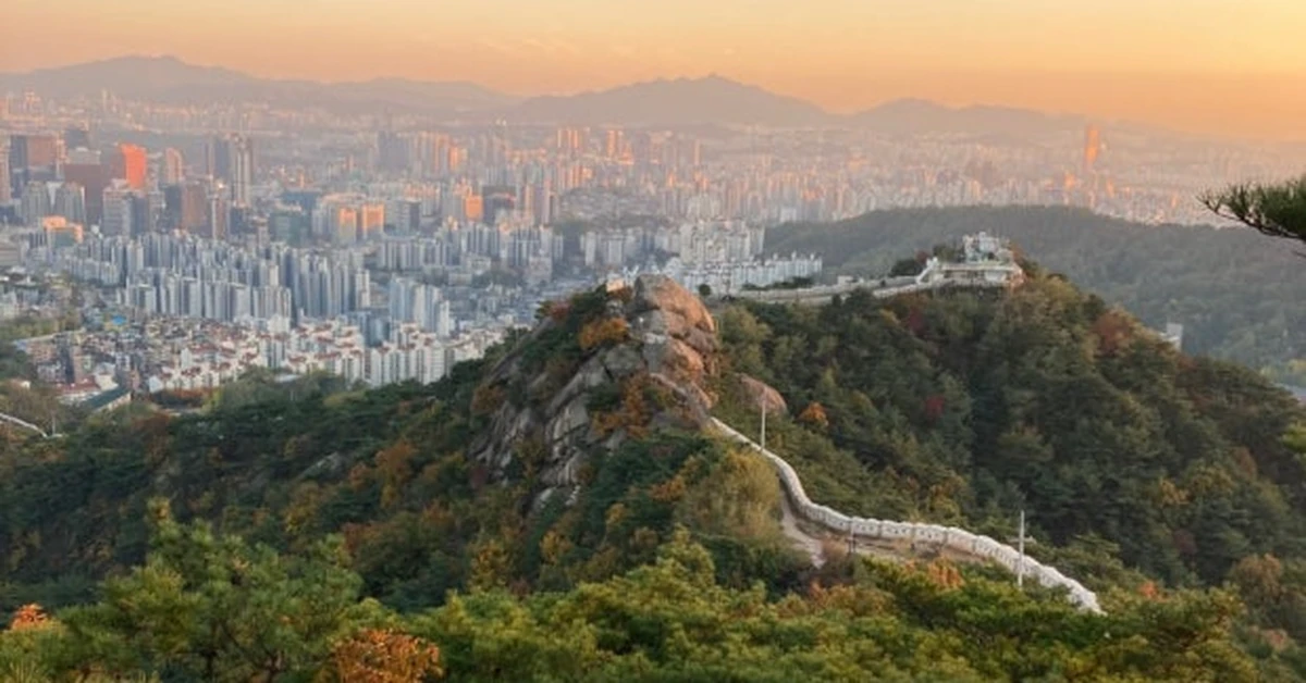
The mountain stands 338 meters above sea level — higher than Namsan — and its defining feature is the exposed granite ridgeline that runs along its spine. Unlike the forested approach to Namsan, Inwangsan opens up quickly. Within twenty minutes of starting the climb, the rock emerges from the trees and the views begin. By the time you reach the summit, you can see Bukhansan’s granite peaks to the north, Namsan Tower to the south, the Gyeongbokgung Palace grounds directly below, and the full sweep of Jongno and central Seoul spreading east and west in between.

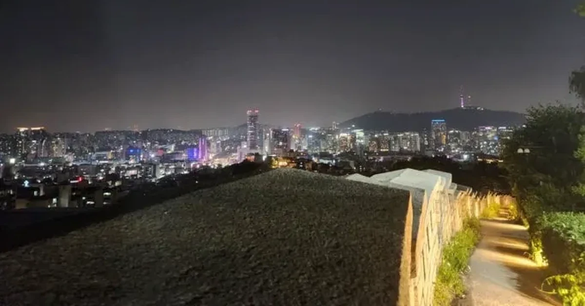
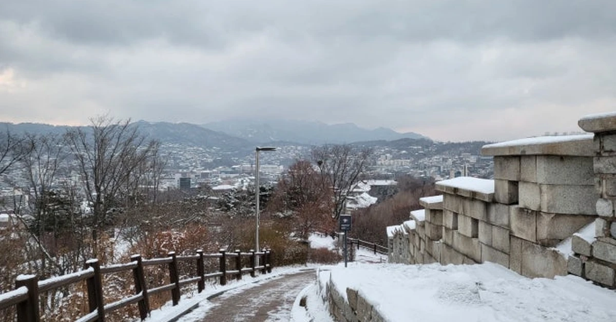
The Seoul City Wall runs along the Inwangsan ridge, and hiking this section places you directly on the ancient fortification stones in a way that feels more immediate than the Namsan section — higher elevation, more exposed, with the city falling away sharply below the wall on one side and the mountain terrain continuing on the other. This is one of those rare situations where a historical structure genuinely earns its scale because you can see exactly what it was designed to defend.
Inwangsan has its own particular character beyond the fortress wall. The mountain is studded with unusual granite rock formations that have been given names and accumulated their own stories over centuries. Seonbawi, the large boulder formation near the base of the mountain that has been a site of shamanic worship for generations, is one of the most quietly atmospheric spots in all of Seoul — a massive, worn rock face at which people still come to pray, surrounded by incense smoke and the particular focused quiet of a site that has been considered sacred for a very long time. The contrast between the contemporary city spreading below and the ancient practice continuing at the rock face is one of those Seoul moments that stops you briefly and makes you think about the depth of everything happening simultaneously in this city.
The evening hike on Inwangsan is particularly celebrated. As the sun drops, the city below begins to illuminate, and the fortress wall stones catch the last warm light in a way that is different from any other time of day. The wall is lit from below after dark, creating a glowing line of stone against the night — one of the most photographed sights on any Seoul mountain. If you can time the summit arrival to about thirty minutes before sunset, the transition from late-afternoon golden light to full city illumination happens around you in a way that’s hard to replicate at any other time or place.
The full hiking course runs approximately 3.1 kilometers from the Inwangsan entrance to Changuimun Gate in the Buam-dong neighborhood, taking about two hours and fifteen minutes at a comfortable pace. The Changuimun Gate end of the trail is particularly beautiful — the old gate, one of the surviving original gates in the Seoul City Wall, sits at the bottom of the trail where it emerges from the mountain into a neighborhood of quiet residential lanes.
Practical details: Take Line 3 to Gyeongbokgung Station, Exit 3, and walk approximately twenty minutes northwest toward Changuimun Gate to reach the main trailhead. Alternatively, Bus 7022 from Gwanghwamun stops near the gate and cuts the walking approach significantly. The mountain is open year-round. Comfortable walking shoes rather than dedicated hiking boots are adequate for most of the trail, though the granite sections can be slippery in wet weather.
Naksan — The Smallest Peak with the Biggest Personality
Naksan is the smallest of the four inner mountains at 125 meters above sea level, and the one least likely to appear on a standard tourist itinerary. This is exactly the reason to visit it.
Covered in Part Five of the Seoul neighborhood series, Naksan Park was mentioned in the context of the city view it provides. But returning to it here in the context of Seoul’s mountains allows for a fuller understanding of what makes it special — because Naksan is less a hiking destination in the conventional sense and more a place where the Seoul City Wall, the urban neighborhood below it, and a genuinely excellent city panorama converge in a space that requires almost no effort to reach and delivers far more than the low elevation would suggest.
The park follows the Seoul City Wall along the ridgeline and is accessible from Hyehwa Station on Line 4, with a twenty-minute uphill walk to the main viewpoint area. The path along the wall is paved and well-lit, which makes Naksan uniquely suitable for evening visits — it’s the easiest of the three mountains in this chapter to reach after dark, and the view of Seoul illuminated from this modest elevation, looking west across the palace district and east toward Dongdaemun, is one of the most satisfying urban panoramas in the city.
What makes Naksan distinctive beyond the view is its connection to the surrounding neighborhood. The Iheha-dong mural village — a hillside residential area whose alleys are covered in paintings — descends the southern slope of Naksan toward the streets below, and the walk from the park viewpoint down through the murals into the neighborhood is one of the best ways to transition from mountain to city in Seoul. You go from the fortress wall and the open view at the top to painted alleyways and the smell of food and coffee at the bottom, and the whole walk takes about fifteen minutes and feels like moving through a series of completely different atmospheres within a single stroll.
The Seoul City Wall path from Naksan connects westward, eventually linking to Inwangsan through the Bugaksan section — which means serious walkers can trace a substantial portion of the ancient fortification’s circuit in a single day. The full Hanyangdoseong trail — all eighteen kilometers — is a well-known challenge for committed hikers, and the Naksan and Inwangsan sections are the most accessible starting points for anyone wanting to experience part of it without committing to the whole circuit.
Practical details: Take Line 4 to Hyehwa Station, Exit 2, and walk uphill following the Seoul City Wall signs. The park is free and open at all hours. Best visited in the late afternoon for the light transition, or after dark for the illuminated wall experience. No specialist footwear required.
Connecting the Three: The Seoul City Wall Experience
One of the more compelling options for visitors who want to experience all three mountains in a single ambitious day is to follow the Seoul Fortress Wall trail that links them.
The Inwangsan, Naksan, and Namsan sections of the Hanyangdoseong trail are each individually described above. Walking them in sequence — starting at Inwangsan in the morning, moving through the Bugaksan section to Naksan by midday, and descending via the Naksan section toward central Seoul before heading south to Namsan for the evening view — creates a day that covers some of the most historic terrain in the city while delivering three completely different mountain personalities.
This is a long day. The full sequence involves around fifteen to twenty kilometers of walking including approach routes, and significant elevation change across the various sections. Solid footwear, plenty of water, and an honest assessment of fitness level are prerequisites. But for those who complete it, the day becomes one of those travel memories that stays very specifically, because it reveals something about Seoul that the ground level never quite communicates — the way the old city wall still holds the shape of a city that has grown enormously in every direction while that ancient ring of stone remains essentially unchanged.
The Hanyangdoseong website issues official completion certificates for hikers who photograph themselves at the four designated points along the full circuit, which adds a mild gamification element that some visitors find satisfying.
Seasonal Notes for All Three Mountains
Spring is the most celebrated hiking season in Seoul, and the inner mountains justify the reputation. Cherry blossoms on the lower slopes of Namsan in late March and early April create an atmosphere that turns an already attractive hike into something memorable. Inwangsan’s pine trees on the upper ridge contrast sharply with the flowering trees visible on the city slopes below, and the combination of color and clear skies that spring typically brings produces the best visibility of the year.
Autumn is equally beautiful, particularly for the color of the trees on Namsan’s forested slopes in October and November. Naksan’s modest deciduous trees turn in the same period, and the late afternoon light on the fortress wall stones during autumn has a warmth that photographers particularly favor.
Summer hiking on all three mountains is viable but demands more preparation — Seoul summers are hot and humid, and even the moderate elevations of the inner mountains build up heat on the ascent. Starting hikes before 9am or after 5pm is strongly recommended in July and August. Bring considerably more water than seems necessary.
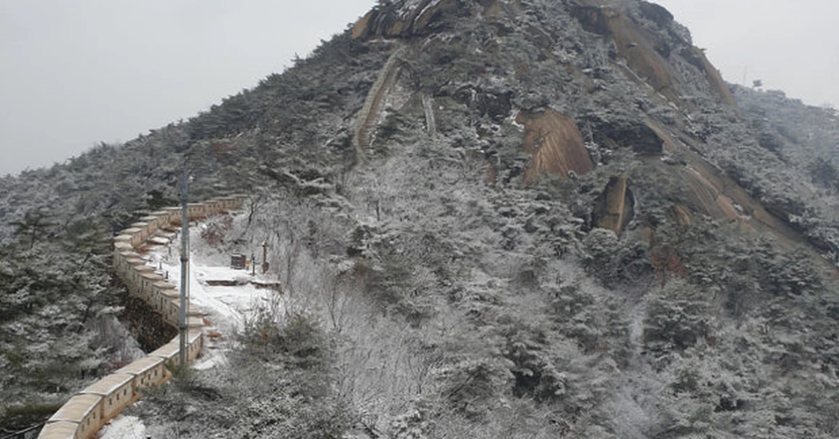
Winter offers a different quality. Snow on the fortress wall stones of Inwangsan, the silent pine forests of Namsan in cold conditions, and the particularly sharp city views that come with cold clear air after a weather front passes through — all of these make winter hikes on the inner mountains genuinely worthwhile, provided appropriate clothing. The illuminated wall on Inwangsan looks particularly striking against a dark winter sky.
Practical Notes for All Three
None of these three mountains requires specialist hiking equipment. Comfortable walking shoes with some grip are adequate for Naksan and for the forested sections of Namsan. The exposed granite sections of Inwangsan benefit from shoes with slightly better traction, particularly in wet conditions, but they are manageable in good athletic shoes.
Water is available at vending machines at the Namsan summit area and at convenience stores near the base of all three mountains. Pack your own supply for Inwangsan, where there are fewer water sources along the ridge.
All three mountains are accessible by subway, which means driving is unnecessary and inadvisable given parking limitations near the trailheads. The T-money card handles all transit. Naver Maps handles the walking routes to each trailhead accurately — search for the Korean name of each mountain (남산, 인왕산, 낙산공원) for the most direct directions.
Photography works best at the summit of Inwangsan in the hour before sunset and at Namsan after the city lights come on fully, around 8pm in winter and 9pm in summer. Naksan is best in the forty-five minutes around sunset from either direction.
Final Thoughts on Part One
The three mountains in this chapter — Namsan with its sweeping view and its famous tower, Inwangsan with its exposed granite ridge and illuminated fortress wall, Naksan with its quiet park and its seamless connection to the neighborhood below — represent Seoul’s most accessible relationship with its natural setting.
None of them demands more than a few hours. All of them deliver more than you’d expect for that investment. And all of them carry the Seoul Fortress Wall along their ridges — those ancient stones that were placed there to define a capital city and have stayed there through six centuries of everything that city became.
Walking them is not hiking in the demanding sense that the next chapter of this series will cover. It’s something closer to what Seoul does better than almost any other major city in the world: making history and nature and contemporary urban life available in the same place, at the same time, with minimal planning required.
Up next — Part 2: The Real Mountains of Seoul — Bukhansan and Dobongsan, where Seoul’s mountains demand real effort and deliver something you can’t find in the city below.
Have you hiked any of Seoul’s inner mountains? Did you catch the fortress wall at night on Inwangsan, or watched the city light up from Namsan? Share your experience in the comments.

